
New Book|"The Geographical Hub of War in Ancient China": What are the battlegrounds
By Souquee Editorial··13 min read·1,616 views
In 1904, the British modern geographer Halford Mackinder read out the paper "The Geographical Hub of History" at the Royal Geographical Society, combining geography with the world political pattern, and proposed the "heartland" and "geography". key concepts such as hubs. Many of the views in the book have a profound impact on the subsequent development of international relations. This paper is also considered to be the foundational work of Western geopolitics.
What is the meaning of the term "geographic hub"? It is generally believed that the war is launched in a certain geographical environment, and its outcome is largely affected by the geographical situation. In a large-scale war, due to its important location, a certain area or a few areas have become a hot spot for the warring parties. ". The origin of geopolitics in China is also very early. For example, in China's earliest military book "The Art of War", the four chapters "Nine Changes", "March", "Topography" and "Nine Lands" specifically expounded the geographical environment and warfare. relationship, which shows the foresight of early thinkers.
In the recently republished "The Geographical Hub of Ancient Wars in China", Song Jie, a professor of history at Beijing Normal University, combined Mackinder's theory with the history of ancient Chinese warfare, and discussed the birth and development of geographic hubs from the Xia Dynasty to the end of the Southern Song Dynasty. and evolution process. Including Gan and Guan in Xia, Shang and Western Zhou, Zheng in the Spring and Autumn War, Han and Wei in Warring States, Hangu Pass and Henan Passage, Aocang in Qin and Han Dynasties, Hefei, Ruxu and Hanzhong in Three Kingdoms, Eastern Jin Shouchun in the Southern Dynasties, the three cities of Heyang from the Northern Dynasties to the middle of the Tang Dynasty, Luoyang in the late Sui and early Tang Dynasties, Xiangyang in the war between Mongolia and the Southern Song Dynasty, and made a comprehensive and systematic study of the strategies, deployment, and routes of the war at that time, and discussed the past dynasties. The success and failure of generals' use of troops, and explore the geographical influence behind the victory and defeat of war.
Whether it is "Qudi", "The Pivot of the World", "Lock and Key" or "Pivot Area", the meanings expressed are basically the same. In a word, it is what people often say "the place where the military must fight".
What are the characteristics of the hub area?
In the ancient Chinese inland wars, the hub area was often located on the edge of the junction of several major economic zones, and it was the only place where the army must pass. , has the dual role of preventing invasion and preparing to attack. At the same time, the hub area must have topographic and hydrological advantages, which can be used as a natural barrier, which is conducive to organizational defense. For example, western Henan is located in mountainous areas, and Huainan and Jingxiang are located along rivers and water networks. The open and flat "Four Battlefields", such as eastern Henan, southern Hebei, and northern Jiangsu, are conducive to the deployment of troops for battles, but there is no danger to defend, and it is difficult to become a hub area.
Song Jie pointed out that if the internal war situation is confrontation between the East and the West, the main area where the two sides confront each other is often the West Henan Corridor at the junction of the East and the West. With Luoyang as the center, it extends to Xingyang in the east, Tongguan in the west, Nanyang Basin in the south, and the Yellow River in the north or the Hedong (middle) area extending to southern Jin. In Chinese history, the peasant war at the end of the Qin Dynasty, the Chu-Han war, the Lulin Chimei peasant war, the Dong Zhuo Rebellion, the war between the Eastern Wei Dynasty and the Northern Qi Dynasty and the Western Wei Dynasty and the Northern Zhou Dynasty, the war between the Li Tang regime and Dou Jiande/Wang Shichong, the Anshi Rebellion, etc. This place is the main battlefield.
If the internal war situation is confrontation between the north and the south, the two sides will mainly carry out the expedition and defense in the Huaihe and Hanshui basins between the Yellow River and the Yangtze River. The hub areas are Huainan (the area south of the Huaihe River and north of the Yangtze River in Jiangsu and Anhui provinces) and Jingxiang (the area around Jiangling, Xiangfan and Hanyang in the north of Hubei, especially Xiangyang). For example, during the Three Kingdoms period, the war between Wei and Shu and the Wu alliance, the confrontation between the Western Jin and the Eastern Wu, the Eastern Jin and the Sixteen Kingdoms, the Southern Dynasty and the Northern Dynasty and the Sui, the Northern Song and the Southern Tang, the Southern Song and the Jin Dynasty and the Yuan Dynasty, are mostly in Huainan, Jingxiang two places.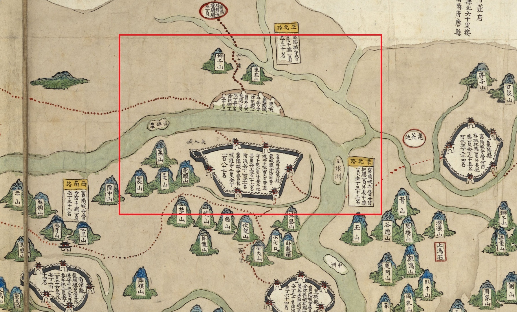
"Battle in the Central Plains": A More Important Inland War Hub
When it comes to important fortifications in the war, the first thing that comes to mind may be the Great Wall on the ancient border, and the cities and fortresses on the border.
Song Jie believes that the status and role of western Henan, Huainan and Jingxiang in the history of war in my country are more important than the pivot areas in the border war. First of all, the frontier war is very long. The nomads in the north are highly mobile and can quickly gather troops. Moreover, the Central Plains Dynasty did not have the strength to station heavy troops everywhere, and could only relatively concentrate the troops in some fortresses. For example, in the middle of the Ming Dynasty, the Mongolian iron cavalry came under the city of Beijing several times, and the Eight Banners of Manchuria in the late Ming Dynasty also bypassed the important town of Shanhaiguan several times, crossed the Great Wall, and ran across North China without major obstacles.
But moving to the mainland, the situation is very different.
The fertile eastern region is divided vertically and horizontally by mountains, hills, and rivers. The passage of large troops is restricted by land and waterways. The front line is short, and the party controlling the hub area can often use the complex and dangerous terrain to effectively block the invasion of powerful enemies. Under the restriction of the main traffic line, it is difficult for the enemy to make long-range strategic detours.
For example, Liu Bang fortified in the narrow areas of Xingyang, Chenggao, and Gongluo, thwarted Xiang Yu's attack, and tried his best to keep Guanzhong from being lost. During the Three Kingdoms period, Cao Wei and Wu and Shu were stalemate, bordering thousands of miles, and they only used heavy troops to defend a few key areas, so they were in an invincible position. Qishan, if thieves come and break under the three cities, there will be a battle for the land." The fall of Tongguan in the Anshi Rebellion and the fall of Xiangyang in the late Southern Song Dynasty all led to the complete collapse of the war situation, reflecting the role played by the inland hub regions in the war. prominent role.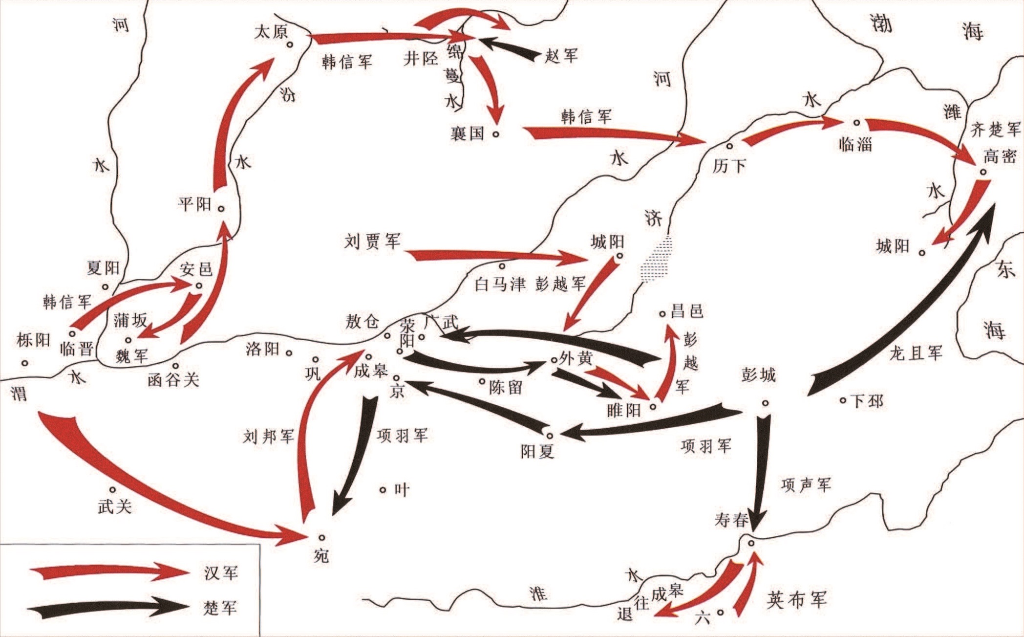
In addition, the scale and strength of border wars are usually limited, and there are relatively few confrontations in the nature of decisive battles. Even if it is a larger battle, for both sides, it can only be regarded as a confrontation in the first line of defense, and both sides still have a lot of room for maneuver. If either side fails, it will not immediately collapse and bow its head. After the defeat of the nomads, they can escape far from the northern desert and the western regions, or retreat into the deep mountains and old forests in the northeast; if the Han people lose, they can move the line of defense southward and rely on the Yellow River, the Huai River, the Yangtze River and the strong mountains to continue the confrontation. The decisive battles that really decided the historical destiny of China's feudal dynasties and the ruling nation all broke out in the interior, the so-called "Battle of the Deer in the Central Plains". Therefore, the influence of inland wars in ancient Chinese history far exceeded that of frontier wars; therefore, the role played by inland hubs in the history of wars was generally more important than that of frontier fortresses.
What is the relationship between the hub area and the location of the capital?
"The Geographical Hub of War in Ancient China" also believes that the hub area is only suitable for the establishment of military hubs and not for the establishment of capitals. If the capital is too close to the border of the basic economic zone, it is vulnerable to enemy invasion in wartime and is often in a passive situation.
There are many such cases in ancient times. For example, in the early Warring States Period, Wei State used Anyi as its capital, facing Qin State across the river, and was repeatedly threatened by enemy forces. Later, the capital was moved eastward to Daliang, and then it got rid of the predicament. Luoyang, the center of the mountainous area of western Henan, also served as the capital or companion capital in the Eastern Han, Sui and Tang Dynasties, and the defense effect was not ideal.
Another example is Luoyang, the capital of the Eastern Han Dynasty. Although it is surrounded by Laoshan, Yique, and the Yellow River, the area is small and lacks defense depth and room for maneuver. The location is in the world, and the roads are connected in all directions, so it is easy for the enemy to attack. Therefore, when Dong Zhuo usurped power at the end of the Han Dynasty, the allied forces of the Guandong princes came to attack, and Dong Zhuo did not dare to defend Luoyang. In the Sui Dynasty, Luoyang was the eastern capital, and it was repeatedly besieged by the rebel forces (Yang Xuangan, Li Mi, Li Shimin) for a long time. During the Anshi Rebellion in the Tang Dynasty, Luoyang, Tokyo, was also lost twice and was occupied by the rebels. The Northern Song Dynasty chose the land and water near the junction of the north and the south to rush to Kaifeng's capital, and the Jurchen iron cavalry also easily surrounded it when it went south, and finally fell.
Investigating the reason, a very important one is: the capital is located on the edge of the basic economic zone, so in times of war, it has to act as a military hub and push the country's political center to the front line of battle, which is tantamount to fighting with others without hands and feet. , and fighting head to toe is naturally very dangerous.
If the capital is located in the center of a basic economic zone, far from the edge, and protected by a strategic hub, it can receive a better defense effect.
For example, Xianyang, the capital of the Qin Dynasty, and Chang'an, the capital of the Western Han Dynasty, are surrounded by fertile fields for thousands of miles, and are also a country of four fortresses. Historically, those who built capitals in the Kanto region chose Hanoi (South of Hebei) as the place to make the tripod. Victory in form. Jiangnan established a country mostly in Jiankang (Jinling), which "has the Dajiang as its control and the Huaidian as its fence", with dragons and tigers, and it attracts the attention of the king.
The above three locations are all around with developed economy and abundant products, which can meet the material needs of the ruling group to a large extent, and are far away from the edge of the basic economic zone where they are located. Can be used as a buffer against direct military threats. Compared with Luoyang and Kaifeng, Chang'an, Yecheng and Jinling as capitals have much better geographical conditions for war defense.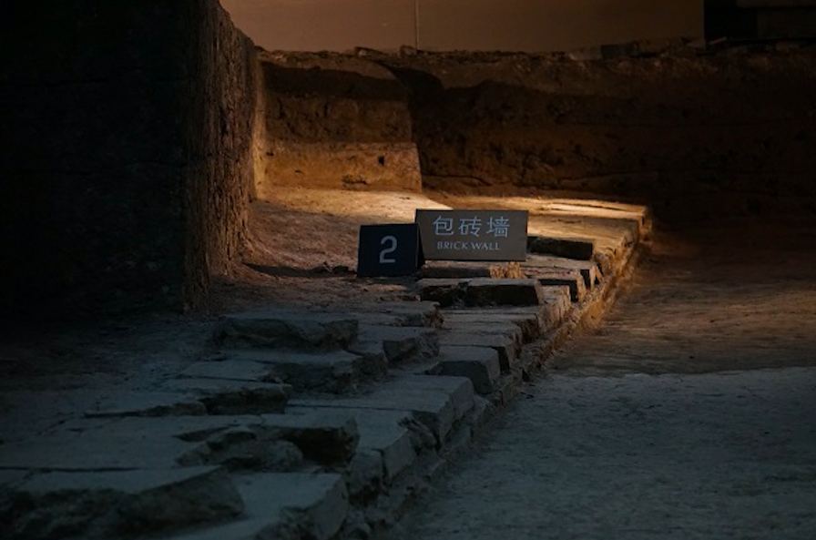
What is the meaning of the term "geographic hub"? It is generally believed that the war is launched in a certain geographical environment, and its outcome is largely affected by the geographical situation. In a large-scale war, due to its important location, a certain area or a few areas have become a hot spot for the warring parties. ". The origin of geopolitics in China is also very early. For example, in China's earliest military book "The Art of War", the four chapters "Nine Changes", "March", "Topography" and "Nine Lands" specifically expounded the geographical environment and warfare. relationship, which shows the foresight of early thinkers.
In the recently republished "The Geographical Hub of Ancient Wars in China", Song Jie, a professor of history at Beijing Normal University, combined Mackinder's theory with the history of ancient Chinese warfare, and discussed the birth and development of geographic hubs from the Xia Dynasty to the end of the Southern Song Dynasty. and evolution process. Including Gan and Guan in Xia, Shang and Western Zhou, Zheng in the Spring and Autumn War, Han and Wei in Warring States, Hangu Pass and Henan Passage, Aocang in Qin and Han Dynasties, Hefei, Ruxu and Hanzhong in Three Kingdoms, Eastern Jin Shouchun in the Southern Dynasties, the three cities of Heyang from the Northern Dynasties to the middle of the Tang Dynasty, Luoyang in the late Sui and early Tang Dynasties, Xiangyang in the war between Mongolia and the Southern Song Dynasty, and made a comprehensive and systematic study of the strategies, deployment, and routes of the war at that time, and discussed the past dynasties. The success and failure of generals' use of troops, and explore the geographical influence behind the victory and defeat of war.
book shadow
Scholars of ancient and modern times have a strong interest in discussing the issue of military affairs. For example, Fan Ju, a strategist during the Warring States Period, made a comprehensive analysis of the geographical situation of various countries, and more clearly called Han and Wei, located in the center of the East Asian continent, "the place of China and the pivot of the world." German military theorist Clausewitz also once said: "In any country there are some particularly important places, where many roads meet, which facilitates the raising of supplies and the ease of movement in all directions. In short, the occupation of these Many needs and many benefits can be met in the place.” He called such areas the “lock and key” of the land.Whether it is "Qudi", "The Pivot of the World", "Lock and Key" or "Pivot Area", the meanings expressed are basically the same. In a word, it is what people often say "the place where the military must fight".
What are the characteristics of the hub area?
In the ancient Chinese inland wars, the hub area was often located on the edge of the junction of several major economic zones, and it was the only place where the army must pass. , has the dual role of preventing invasion and preparing to attack. At the same time, the hub area must have topographic and hydrological advantages, which can be used as a natural barrier, which is conducive to organizational defense. For example, western Henan is located in mountainous areas, and Huainan and Jingxiang are located along rivers and water networks. The open and flat "Four Battlefields", such as eastern Henan, southern Hebei, and northern Jiangsu, are conducive to the deployment of troops for battles, but there is no danger to defend, and it is difficult to become a hub area.
Song Jie pointed out that if the internal war situation is confrontation between the East and the West, the main area where the two sides confront each other is often the West Henan Corridor at the junction of the East and the West. With Luoyang as the center, it extends to Xingyang in the east, Tongguan in the west, Nanyang Basin in the south, and the Yellow River in the north or the Hedong (middle) area extending to southern Jin. In Chinese history, the peasant war at the end of the Qin Dynasty, the Chu-Han war, the Lulin Chimei peasant war, the Dong Zhuo Rebellion, the war between the Eastern Wei Dynasty and the Northern Qi Dynasty and the Western Wei Dynasty and the Northern Zhou Dynasty, the war between the Li Tang regime and Dou Jiande/Wang Shichong, the Anshi Rebellion, etc. This place is the main battlefield.
If the internal war situation is confrontation between the north and the south, the two sides will mainly carry out the expedition and defense in the Huaihe and Hanshui basins between the Yellow River and the Yangtze River. The hub areas are Huainan (the area south of the Huaihe River and north of the Yangtze River in Jiangsu and Anhui provinces) and Jingxiang (the area around Jiangling, Xiangfan and Hanyang in the north of Hubei, especially Xiangyang). For example, during the Three Kingdoms period, the war between Wei and Shu and the Wu alliance, the confrontation between the Western Jin and the Eastern Wu, the Eastern Jin and the Sixteen Kingdoms, the Southern Dynasty and the Northern Dynasty and the Sui, the Northern Song and the Southern Tang, the Southern Song and the Jin Dynasty and the Yuan Dynasty, are mostly in Huainan, Jingxiang two places.
Xiangfan area in the painted map of Hubei in Qing Dynasty
In addition, in ancient China, there were many areas with unique military value, such as the Sichuan Basin, which was basically an independent economic region, which was not classified as Kansai or Jiangnan. When the northern political forces moved southward, they often crossed the Qinling Mountains, entered the Sichuan Basin through Hanzhong, and then either left the Three Gorges in the east, or went south to Yungui, and surrounded Jiangnan with flanks. Therefore, Hanzhong at the junction of Sichuan and Shaanxi was also a pivotal area of the Civil War. However, its role and influence were not as great as those of Huainan and Jingxiang, because Hanzhong was far away from Jiangsu and Zhejiang, the ruling center of the southern regime, and could not pose a direct threat. Even if the northern forces occupied Sichuan, the separatist regime in the south of the Yangtze River would not soon perish. For example, after Cao Wei destroyed Shu, and the Northern Zhou Dynasty and Mongolia took over Sichuan, Soochow Wu, Chen and Southern Song Dynasty could still maintain their rule."Battle in the Central Plains": A More Important Inland War Hub
When it comes to important fortifications in the war, the first thing that comes to mind may be the Great Wall on the ancient border, and the cities and fortresses on the border.
Song Jie believes that the status and role of western Henan, Huainan and Jingxiang in the history of war in my country are more important than the pivot areas in the border war. First of all, the frontier war is very long. The nomads in the north are highly mobile and can quickly gather troops. Moreover, the Central Plains Dynasty did not have the strength to station heavy troops everywhere, and could only relatively concentrate the troops in some fortresses. For example, in the middle of the Ming Dynasty, the Mongolian iron cavalry came under the city of Beijing several times, and the Eight Banners of Manchuria in the late Ming Dynasty also bypassed the important town of Shanhaiguan several times, crossed the Great Wall, and ran across North China without major obstacles.
But moving to the mainland, the situation is very different.
The fertile eastern region is divided vertically and horizontally by mountains, hills, and rivers. The passage of large troops is restricted by land and waterways. The front line is short, and the party controlling the hub area can often use the complex and dangerous terrain to effectively block the invasion of powerful enemies. Under the restriction of the main traffic line, it is difficult for the enemy to make long-range strategic detours.
For example, Liu Bang fortified in the narrow areas of Xingyang, Chenggao, and Gongluo, thwarted Xiang Yu's attack, and tried his best to keep Guanzhong from being lost. During the Three Kingdoms period, Cao Wei and Wu and Shu were stalemate, bordering thousands of miles, and they only used heavy troops to defend a few key areas, so they were in an invincible position. Qishan, if thieves come and break under the three cities, there will be a battle for the land." The fall of Tongguan in the Anshi Rebellion and the fall of Xiangyang in the late Southern Song Dynasty all led to the complete collapse of the war situation, reflecting the role played by the inland hub regions in the war. prominent role.
Schematic diagram of the Han army's exit and attack in the Chu-Han War (205 BC)
Therefore, there is a saying that "Hu has no luck for a hundred years". Affected by this characteristic, in the various stages of the feudal society, the frontier peoples that were sharply opposed to the Central Plains dynasties were not the same, and even the early, middle and late stages of a dynasty were different, such as the Eastern Han and the Xiongnu and Qiang, the Tang Dynasty. With the Turks, Tubo and Nanzhao, and the Ming Dynasty with Mongolia and the Jurchen, the places of conflict and war were frequently shifted. The pivot areas of border wars existed for a short period of time, such as Victoria in the late Tang Dynasty and Shanhaiguan in the late Ming Dynasty, etc. Therefore, their influence in military history was limited. Unlike the western Henan, Huainan, and Jingxiang in the mainland, they had an important strategic position for more than a thousand years, even in the entire feudal era of China.In addition, the scale and strength of border wars are usually limited, and there are relatively few confrontations in the nature of decisive battles. Even if it is a larger battle, for both sides, it can only be regarded as a confrontation in the first line of defense, and both sides still have a lot of room for maneuver. If either side fails, it will not immediately collapse and bow its head. After the defeat of the nomads, they can escape far from the northern desert and the western regions, or retreat into the deep mountains and old forests in the northeast; if the Han people lose, they can move the line of defense southward and rely on the Yellow River, the Huai River, the Yangtze River and the strong mountains to continue the confrontation. The decisive battles that really decided the historical destiny of China's feudal dynasties and the ruling nation all broke out in the interior, the so-called "Battle of the Deer in the Central Plains". Therefore, the influence of inland wars in ancient Chinese history far exceeded that of frontier wars; therefore, the role played by inland hubs in the history of wars was generally more important than that of frontier fortresses.
What is the relationship between the hub area and the location of the capital?
"The Geographical Hub of War in Ancient China" also believes that the hub area is only suitable for the establishment of military hubs and not for the establishment of capitals. If the capital is too close to the border of the basic economic zone, it is vulnerable to enemy invasion in wartime and is often in a passive situation.
There are many such cases in ancient times. For example, in the early Warring States Period, Wei State used Anyi as its capital, facing Qin State across the river, and was repeatedly threatened by enemy forces. Later, the capital was moved eastward to Daliang, and then it got rid of the predicament. Luoyang, the center of the mountainous area of western Henan, also served as the capital or companion capital in the Eastern Han, Sui and Tang Dynasties, and the defense effect was not ideal.
Another example is Luoyang, the capital of the Eastern Han Dynasty. Although it is surrounded by Laoshan, Yique, and the Yellow River, the area is small and lacks defense depth and room for maneuver. The location is in the world, and the roads are connected in all directions, so it is easy for the enemy to attack. Therefore, when Dong Zhuo usurped power at the end of the Han Dynasty, the allied forces of the Guandong princes came to attack, and Dong Zhuo did not dare to defend Luoyang. In the Sui Dynasty, Luoyang was the eastern capital, and it was repeatedly besieged by the rebel forces (Yang Xuangan, Li Mi, Li Shimin) for a long time. During the Anshi Rebellion in the Tang Dynasty, Luoyang, Tokyo, was also lost twice and was occupied by the rebels. The Northern Song Dynasty chose the land and water near the junction of the north and the south to rush to Kaifeng's capital, and the Jurchen iron cavalry also easily surrounded it when it went south, and finally fell.
Investigating the reason, a very important one is: the capital is located on the edge of the basic economic zone, so in times of war, it has to act as a military hub and push the country's political center to the front line of battle, which is tantamount to fighting with others without hands and feet. , and fighting head to toe is naturally very dangerous.
If the capital is located in the center of a basic economic zone, far from the edge, and protected by a strategic hub, it can receive a better defense effect.
For example, Xianyang, the capital of the Qin Dynasty, and Chang'an, the capital of the Western Han Dynasty, are surrounded by fertile fields for thousands of miles, and are also a country of four fortresses. Historically, those who built capitals in the Kanto region chose Hanoi (South of Hebei) as the place to make the tripod. Victory in form. Jiangnan established a country mostly in Jiankang (Jinling), which "has the Dajiang as its control and the Huaidian as its fence", with dragons and tigers, and it attracts the attention of the king.
The above three locations are all around with developed economy and abundant products, which can meet the material needs of the ruling group to a large extent, and are far away from the edge of the basic economic zone where they are located. Can be used as a buffer against direct military threats. Compared with Luoyang and Kaifeng, Chang'an, Yecheng and Jinling as capitals have much better geographical conditions for war defense.
Rammed earth and bricks on display at the Nanjing Six Dynasties Museum The city wall of Kangcheng built in the Six Dynasties